
Town of Clarkstown topographic map
Interactive map
Click on the map to display elevation.
About this map
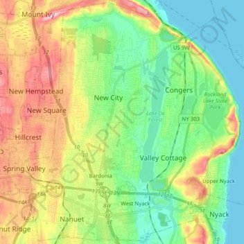
Name: Town of Clarkstown topographic map, elevation, terrain.
Location: Town of Clarkstown, Rockland County, New York, United States (41.07832 -74.04169 41.19251 -73.89000)
Average elevation: 60 m
Minimum elevation: 0 m
Maximum elevation: 231 m
Other topographic maps
Click on a map to view its topography, its elevation and its terrain.
Village of Spring Valley
United States > New York > Rockland County
Village of Spring Valley, Town of Ramapo, Rockland County, New York, 10977, United States
Average elevation: 149 m
Village of West Haverstraw
United States > New York > Rockland County > Town of Haverstraw
Village of West Haverstraw, Town of Haverstraw, Rockland County, New York, United States
Average elevation: 62 m
Evans Park Trail/Woods
United States > New York > Rockland County > Pearl River
Evans Park Trail/Woods, Pearl River, Town of Orangetown, Rockland County, New York, United States
Average elevation: 82 m
Valley Cottage
United States > New York > Rockland County
Valley Cottage, Town of Clarkstown, Rockland County, New York, 10989, United States
Average elevation: 63 m
Rockland Lake
United States > New York > Rockland County > Congers
Rockland Lake, Congers, Town of Clarkstown, Rockland County, New York, 10920, United States
Average elevation: 58 m
Village of Pomona
United States > New York > Rockland County > Town of Haverstraw
Village of Pomona, Town of Haverstraw, Rockland County, New York, United States
Average elevation: 186 m
Thiells
United States > New York > Rockland County > Town of Haverstraw
Thiells, Town of Haverstraw, Rockland County, New York, 10984, United States
Average elevation: 114 m
Tomkins Cove
United States > New York > Rockland County > Town of Stony Point
Tomkins Cove, Town of Stony Point, Rockland County, New York, 10986, United States
Average elevation: 68 m
Sparkill
United States > New York > Rockland County
Sparkill, Town of Orangetown, Rockland County, New York, 10976, United States
Average elevation: 30 m
Village of Wesley Hills
United States > New York > Rockland County
Village of Wesley Hills, Town of Ramapo, Rockland County, New York, United States
Average elevation: 164 m
Nanuet
United States > New York > Rockland County
Nanuet, Town of Clarkstown, Rockland County, New York, 10954, United States
Average elevation: 104 m
New City Park
United States > New York > Rockland County > New City
New City Park, New City, Town of Clarkstown, Rockland County, New York, 10956, United States
Average elevation: 99 m
Tappan
United States > New York > Rockland County
Tappan, Town of Orangetown, Rockland County, New York, 10983, United States
Average elevation: 34 m
Buckberg
United States > New York > Rockland County > Town of Stony Point
Buckberg, Town of Stony Point, Rockland County, New York, 10986, United States
Average elevation: 108 m
Lake Welch
United States > New York > Rockland County > Town of Stony Point
Lake Welch, Town of Stony Point, Rockland County, New York, United States
Average elevation: 324 m
Village of Nyack
United States > New York > Rockland County
Village of Nyack, Town of Orangetown, Rockland County, New York, 10960, United States
Average elevation: 50 m
Garnerville
United States > New York > Rockland County > Village of West Haverstraw
Garnerville, Village of West Haverstraw, Town of Haverstraw, Rockland County, New York, 10923, United States
Average elevation: 80 m
Bear Mountain State Park
United States > New York > Rockland County > Town of Stony Point
Bear Mountain State Park, Town of Stony Point, Town of Highlands, Rockland County, New York, United States
Average elevation: 166 m
Town of Stony Point
United States > New York > Rockland County
Town of Stony Point, Rockland County, New York, United States
Average elevation: 119 m
Village of Montebello
United States > New York > Rockland County
Village of Montebello, Town of Ramapo, Rockland County, New York, 10901, United States
Average elevation: 149 m
Village of Piermont
United States > New York > Rockland County
Village of Piermont, Town of Orangetown, Rockland County, New York, 10968, United States
Average elevation: 38 m
New City
United States > New York > Rockland County
New City, Town of Clarkstown, Rockland County, New York, 10956, United States
Average elevation: 89 m
Suffern
United States > New York > Rockland County > Suffern > Suffern
Suffern, Town of Ramapo, Rockland County, New York, 07495, United States
Average elevation: 159 m
Village of Suffern
United States > New York > Rockland County
Village of Suffern, Town of Ramapo, Rockland County, New York, United States
Average elevation: 114 m
West Nyack
United States > New York > Rockland County
West Nyack, Town of Clarkstown, Rockland County, New York, 10994, United States
Average elevation: 46 m
Mount Ivy
United States > New York > Rockland County
Mount Ivy, Town of Haverstraw, Rockland County, New York, 10970, United States
Average elevation: 123 m
Monsey
United States > New York > Rockland County
Monsey, Town of Ramapo, Rockland County, New York, 10952, United States
Average elevation: 172 m
Airmont
United States > New York > Rockland County > Airmont
Airmont, Town of Ramapo, Rockland County, New York, 10982, United States
Average elevation: 146 m
Palisades
United States > New York > Rockland County > Palisades > Palisades
Palisades, Town of Orangetown, Rockland County, New York, 10964, United States
Average elevation: 36 m
Stony Point
United States > New York > Rockland County > Stony Point
Stony Point, Town of Stony Point, Rockland County, New York, 10980, United States
Average elevation: 71 m
Village of Hillburn
United States > New York > Rockland County
Village of Hillburn, Town of Ramapo, Rockland County, New York, 10931, United States
Average elevation: 182 m
Doodletown
United States > New York > Rockland County > Doodletown
Doodletown, Town of Stony Point, Rockland County, New York, 10911, United States
Average elevation: 178 m
Village of Upper Nyack
United States > New York > Rockland County
Village of Upper Nyack, Town of Clarkstown, Rockland County, New York, United States
Average elevation: 61 m
Orangeburg
United States > New York > Rockland County
Orangeburg, Town of Orangetown, Rockland County, New York, 10962, United States
Average elevation: 67 m
Village of Haverstraw
United States > New York > Rockland County > Town of Haverstraw
Village of Haverstraw, Town of Haverstraw, Rockland County, New York, 10927, United States
Average elevation: 44 m