
Nashik topographic map
Interactive map
Click on the map to display elevation.
About this map
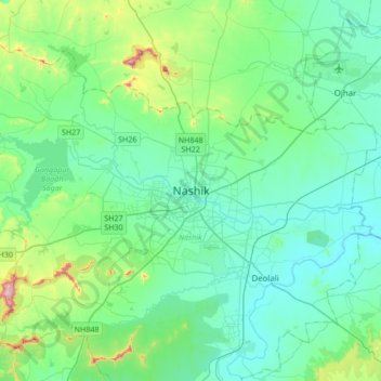
Name: Nashik topographic map, elevation, terrain.
Location: Nashik, Maharashtra, 422001, Indien (19.85125 73.63024 20.17125 73.95024)
Average elevation: 631 m
Minimum elevation: 535 m
Maximum elevation: 1,079 m
Nashik liegt im Norden der Westghats am heiligen Fluss Godavari in einer Höhe von etwa 570 m. Die Stadt Mumbai befindet sich etwa 165 km (Fahrtstrecke) südwestlich; die indische Hauptstadt Delhi liegt etwa 1250 km nordöstlich. Das Klima ist warm; Regen (ca. 810 mm/Jahr) fällt eigentlich nur während der sommerlichen Monsunzeit.