
Make a donation
Gear up for your next adventure:
As an Amazon Associate, this site earns from qualifying purchases at no extra cost to you.
Corcovado topographic map
Click on the map to display elevation.
Make a donation
Gear up for your next adventure:
As an Amazon Associate, this site earns from qualifying purchases at no extra cost to you.
About this map
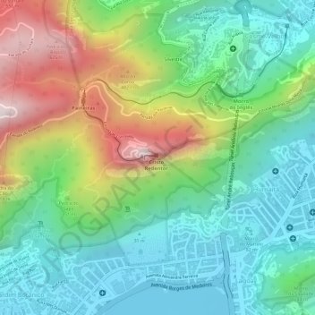
Name: Corcovado topographic map, elevation, terrain.
Average elevation: 221 m
Minimum elevation: 1 m
Maximum elevation: 635 m
Make a donation
Gear up for your next adventure:
As an Amazon Associate, this site earns from qualifying purchases at no extra cost to you.
Other topographic maps
Click on a map to view its topography, its elevation and its terrain.
São Francisco Xavier
Brazil > Rio de Janeiro > Região Metropolitana do Rio de Janeiro > Rio de Janeiro
Average elevation: 35 m
Santa Teresa
Brazil > Rio de Janeiro > Região Metropolitana do Rio de Janeiro > Rio de Janeiro
Around 1850 many people, fleeing the yellow fever epidemic in the city, flocked to the neighborhood. As it was at a higher altitude, Santa Teresa was less affected by the epidemic than the surrounding neighborhoods.
Average elevation: 55 m
Alto da Boa Vista
Brazil > Rio de Janeiro > Região Metropolitana do Rio de Janeiro > Rio de Janeiro
Average elevation: 245 m
Copacabana Beach
Brazil > Rio de Janeiro > Região Metropolitana do Rio de Janeiro > Rio de Janeiro
Average elevation: 38 m
Make a donation
Gear up for your next adventure:
As an Amazon Associate, this site earns from qualifying purchases at no extra cost to you.
Botafogo
Brazil > Rio de Janeiro > Região Metropolitana do Rio de Janeiro > Rio de Janeiro
Average elevation: 52 m
Quinta da Boa Vista
Brazil > Rio de Janeiro > Região Metropolitana do Rio de Janeiro > Rio de Janeiro
Average elevation: 19 m
Jacarezinho
Brazil > Rio de Janeiro > Região Metropolitana do Rio de Janeiro > Rio de Janeiro
Average elevation: 18 m
Copacabana
Brazil > Rio de Janeiro > Região Metropolitana do Rio de Janeiro > Rio de Janeiro
Average elevation: 41 m
Make a donation
Gear up for your next adventure:
As an Amazon Associate, this site earns from qualifying purchases at no extra cost to you.
Copacabana
Brazil > Rio de Janeiro > Região Metropolitana do Rio de Janeiro > Rio de Janeiro
Average elevation: 41 m
Praça Heitor Bastos Tigre
Brazil > Rio de Janeiro > Região Metropolitana do Rio de Janeiro > Rio de Janeiro
Average elevation: 7 m
Méier
Brazil > Rio de Janeiro > Região Metropolitana do Rio de Janeiro > Rio de Janeiro
Average elevation: 38 m
Campo Grande
Brazil > Rio de Janeiro > Região Metropolitana do Rio de Janeiro > Rio de Janeiro
Average elevation: 113 m
Make a donation
Gear up for your next adventure:
As an Amazon Associate, this site earns from qualifying purchases at no extra cost to you.
Vasco da Gama
Brazil > Rio de Janeiro > Região Metropolitana do Rio de Janeiro > Rio de Janeiro
Average elevation: 15 m
Vidigal
Brazil > Rio de Janeiro > Região Metropolitana do Rio de Janeiro > Rio de Janeiro
Average elevation: 79 m
Vista Alegre
Brazil > Rio de Janeiro > Região Metropolitana do Rio de Janeiro > Rio de Janeiro
Average elevation: 18 m
Lins de Vasconcelos
Brazil > Rio de Janeiro > Região Metropolitana do Rio de Janeiro > Rio de Janeiro
Average elevation: 128 m
Make a donation
Gear up for your next adventure:
As an Amazon Associate, this site earns from qualifying purchases at no extra cost to you.
Botafogo
Brazil > Rio de Janeiro > Região Metropolitana do Rio de Janeiro > Rio de Janeiro
Average elevation: 52 m
São Conrado
Brazil > Rio de Janeiro > Região Metropolitana do Rio de Janeiro > Rio de Janeiro
Average elevation: 115 m
Bangu
Brazil > Rio de Janeiro > Região Metropolitana do Rio de Janeiro > Rio de Janeiro
Average elevation: 119 m
Rocha
Brazil > Rio de Janeiro > Região Metropolitana do Rio de Janeiro > Rio de Janeiro
Average elevation: 35 m
Make a donation
Gear up for your next adventure:
As an Amazon Associate, this site earns from qualifying purchases at no extra cost to you.
Engenho de Dentro
Brazil > Rio de Janeiro > Região Metropolitana do Rio de Janeiro > Rio de Janeiro
Average elevation: 87 m
Jacarezinho
Brazil > Rio de Janeiro > Região Metropolitana do Rio de Janeiro > Rio de Janeiro
Average elevation: 18 m
Santa Teresa
Brazil > Rio de Janeiro > Região Metropolitana do Rio de Janeiro > Rio de Janeiro
Around 1850 many people, fleeing the yellow fever epidemic in the city, flocked to the neighborhood. As it was at a higher altitude, Santa Teresa was less affected by the epidemic than the surrounding neighborhoods.
Average elevation: 55 m
Rocinha
Brazil > Rio de Janeiro > Região Metropolitana do Rio de Janeiro > Rio de Janeiro
Average elevation: 161 m
Make a donation
Gear up for your next adventure:
As an Amazon Associate, this site earns from qualifying purchases at no extra cost to you.
Ipanema
Brazil > Rio de Janeiro > Região Metropolitana do Rio de Janeiro > Rio de Janeiro
Average elevation: 10 m
Vidigal
Brazil > Rio de Janeiro > Região Metropolitana do Rio de Janeiro > Rio de Janeiro
Average elevation: 79 m
Praia do Leblon
Brazil > Rio de Janeiro > Região Metropolitana do Rio de Janeiro > Rio de Janeiro
Average elevation: 26 m
Copacabana Beach
Brazil > Rio de Janeiro > Região Metropolitana do Rio de Janeiro > Rio de Janeiro
Average elevation: 38 m
Make a donation
Gear up for your next adventure:
As an Amazon Associate, this site earns from qualifying purchases at no extra cost to you.
Cidade de Deus
Brazil > Rio de Janeiro > Região Metropolitana do Rio de Janeiro > Rio de Janeiro
Average elevation: 12 m