
Make a donation
Gear up for your next adventure:
As an Amazon Associate, this site earns from qualifying purchases at no extra cost to you.
Macedo de Cavaleiros topographic map
Click on the map to display elevation.
Make a donation
Gear up for your next adventure:
As an Amazon Associate, this site earns from qualifying purchases at no extra cost to you.
Macedo de Cavaleiros
The municipality of Macedo de Cavaleiros is situated in the northeast region of the Trás-os-Montes, within the district of Bragança, limited by the neighbouring administrations of Bragança, Vinhais, Mirandela, Alfândega da Fé, Mogadouro and Vimioso. It occupies the central part of the district, in a transitional zone between the distinctly different Terra Fria (Cold Lands) and Terra Quente (Hot Lands). The median altitude in the municipality is between 600 and 700 metres, marked in the north by the Serra de Nogueira, in the centre by the Serra de Ala and Serra do Cubo, and in the south by the Serra de Bornes and the Monte de Morais.
Make a donation
Gear up for your next adventure:
As an Amazon Associate, this site earns from qualifying purchases at no extra cost to you.
About this map
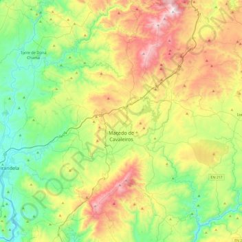
Name: Macedo de Cavaleiros topographic map, elevation, terrain.
Location: Macedo de Cavaleiros, Bragança, Portugal (41.40369 -7.12956 41.71131 -6.65856)
Average elevation: 594 m
Minimum elevation: 198 m
Maximum elevation: 1,312 m
Make a donation
Gear up for your next adventure:
As an Amazon Associate, this site earns from qualifying purchases at no extra cost to you.
Other topographic maps
Click on a map to view its topography, its elevation and its terrain.