
Make a donation
Gear up for your next adventure:
As an Amazon Associate, this site earns from qualifying purchases at no extra cost to you.
Carmona topographic map
Click on the map to display elevation.
Make a donation
Gear up for your next adventure:
As an Amazon Associate, this site earns from qualifying purchases at no extra cost to you.
Carmona
The topography of Carmona is generally flat to strongly rolling or sloping, partly lowland and partly hill. Carmona is divided into four physiographical areas: the lowest lowland area, the lowland area, the central hilly area and the upland mountainous area.
Make a donation
Gear up for your next adventure:
As an Amazon Associate, this site earns from qualifying purchases at no extra cost to you.
About this map
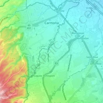
Name: Carmona topographic map, elevation, terrain.
Location: Carmona, Cavite, Calabarzon, 4116, Philippines (14.25715 121.00258 14.32913 121.07768)
Average elevation: 56 m
Minimum elevation: 8 m
Maximum elevation: 212 m
Make a donation
Gear up for your next adventure:
As an Amazon Associate, this site earns from qualifying purchases at no extra cost to you.
Other topographic maps
Click on a map to view its topography, its elevation and its terrain.