
Ermoupoli topographic map
Interactive map
Click on the map to display elevation.
About this map
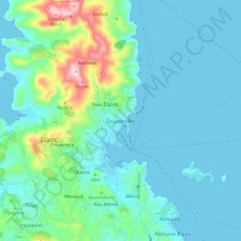
Name: Ermoupoli topographic map, elevation, terrain.
Average elevation: 75 m
Minimum elevation: 0 m
Maximum elevation: 438 m
Other topographic maps
Click on a map to view its topography, its elevation and its terrain.
Καμάρα
Greece > Aegean > Syros Regional Unit > Ano Syros
Καμάρα, Ano Syros, Municipality of Syros and Ermoupoli, Syros Regional Unit, South Aegean, Aegean, 841 00, Greece
Average elevation: 119 m
Syros
Greece > Aegean > Syros Regional Unit > Mesaria
Syros, Mesaria, Municipality of Syros and Ermoupoli, Syros Regional Unit, South Aegean, Aegean, 841 00, Greece
Average elevation: 32 m
Malia
Greece > Aegean > Syros Regional Unit > Episkopio
Malia, Episkopio, Municipality of Syros and Ermoupoli, Syros Regional Unit, South Aegean, Aegean, 841 00, Greece
Average elevation: 95 m
Municipality of Syros and Ermoupoli
Greece > Aegean > Syros Regional Unit
Municipality of Syros and Ermoupoli, Syros Regional Unit, South Aegean, Aegean, 841 00, Greece
Average elevation: 20 m