
Westoutre topographic map
Interactive map
Click on the map to display elevation.
About this map
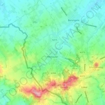
Name: Westoutre topographic map, elevation, terrain.
Location: Westoutre, Heuvelland, Ypres, Flandre-Occidentale, Belgique (50.77346 2.71302 50.82732 2.77246)
Average elevation: 59 m
Minimum elevation: 21 m
Maximum elevation: 151 m
Other topographic maps
Click on a map to view its topography, its elevation and its terrain.
Locre
Belgique > Flandre-Occidentale > Ypres > Heuvelland
Locre, Heuvelland, Ypres, Flandre-Occidentale, Flandre, 8958, Belgique
Average elevation: 73 m
Dranoutre
Belgique > Flandre-Occidentale > Ypres > Heuvelland
Dranoutre, Heuvelland, Ypres, Flandre-Occidentale, 8951, Belgique
Average elevation: 50 m
Wytschaete
Belgique > Flandre-Occidentale > Ypres > Heuvelland
Wytschaete, Heuvelland, Ypres, Flandre-Occidentale, Flandre, 8953, Belgique
Average elevation: 42 m
Kemmel
Belgique > Flandre-Occidentale > Ypres > Heuvelland
Kemmel, Heuvelland, Ypres, Flandre-Occidentale, 8956, Belgique
Average elevation: 49 m