
Prats de Padouen topographic map
Interactive map
Click on the map to display elevation.
About this map
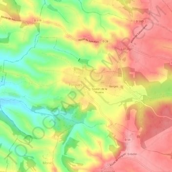
Name: Prats de Padouen topographic map, elevation, terrain.
Average elevation: 282 m
Minimum elevation: 208 m
Maximum elevation: 341 m
Other topographic maps
Click on a map to view its topography, its elevation and its terrain.
Berges
France > Occitanie > Haute-Garonne > Forgues
Berges, Forgues, Muret, Haute-Garonne, Occitanie, France métropolitaine, 31370, France
Average elevation: 292 m