
Make a donation
Gear up for your next adventure:
As an Amazon Associate, this site earns from qualifying purchases at no extra cost to you.
Werbomont topographic map
Click on the map to display elevation.
Make a donation
Gear up for your next adventure:
As an Amazon Associate, this site earns from qualifying purchases at no extra cost to you.
About this map
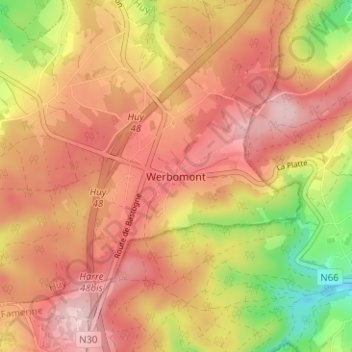
Name: Werbomont topographic map, elevation, terrain.
Location: Werbomont, Ferrières, Huy, Liège, Wallonia, 4190, Belgium (50.36001 5.66680 50.40001 5.70680)
Average elevation: 402 m
Minimum elevation: 269 m
Maximum elevation: 483 m
Make a donation
Gear up for your next adventure:
As an Amazon Associate, this site earns from qualifying purchases at no extra cost to you.
Other topographic maps
Click on a map to view its topography, its elevation and its terrain.
Make a donation
Gear up for your next adventure:
As an Amazon Associate, this site earns from qualifying purchases at no extra cost to you.
Engis
In late 1930 and early 1931, several thousand cases of acute pulmonary attacks occurred in the Meuse valley, centered on Engis, and 60 people died. A commission of inquiry set up by the Belgian government concluded that the cause was poisonous waste gases, primarily sulfur dioxide, emitted by the many…
Average elevation: 171 m
Make a donation
Gear up for your next adventure:
As an Amazon Associate, this site earns from qualifying purchases at no extra cost to you.