Geolocate

Launceston topographic map

Click on the map to display elevation.

Launceston

Launceston is at 41°26′31″S 147°8′42″E / 41.44194°S 147.14500°E / -41.44194; 147.14500 in the Tamar Valley, Northern Tasmania. The valley was formed by volcanic and glacial forces over 10 million years ago. The city is about 45 kilometres (28 mi) south of the Bass Strait, with its closest neighbour-city being Devonport, about 99 kilometres (62 mi) to the north west. Launceston combines steep (originally heavily wooded) ridges and low-lying areas (originally wetlands – with parts of the suburbs of Inveresk and Invermay below high-tide level). As a result, areas of Launceston are subject to landslip problems, while others are liable to poor drainage and periodic flooding. The topography of the area is not conducive to easy dispersion of airborne pollution, due to the phenomenon of thermal inversion.

About this map

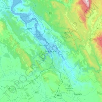
Name: Launceston topographic map, elevation, terrain.

Location: Launceston, Tasmania, 7250, Australia (-41.59408 146.97735 -41.27408 147.29735)

Average elevation: 218 m

Minimum elevation: -3 m

Maximum elevation: 1,171 m

Tasmania trails, hiking, mountain biking, running and outdoor activities

Other topographic maps

Click on a map to view its topography, its elevation and its terrain.

Prospect Vale

Australia > Tasmania > Launceston

Average elevation: 174 m

Invermay

Australia > Tasmania > Launceston

Average elevation: 5 m

South Esk River

Australia > Tasmania > Launceston

Average elevation: 153 m

St Leonards

Australia > Tasmania > Launceston

Average elevation: 122 m

Riverside

Australia > Tasmania > Launceston

Average elevation: 111 m

Trevallyn

Australia > Tasmania > Launceston

Average elevation: 103 m

Rocherlea

Australia > Tasmania > Launceston

Average elevation: 117 m

Blackstone Heights

Australia > Tasmania > Launceston

Average elevation: 171 m

Riverside

Australia > Tasmania > Launceston

Average elevation: 111 m

Waverley

Australia > Tasmania > Launceston

Average elevation: 109 m

East Launceston

Australia > Tasmania > Launceston

Average elevation: 24 m

Prospect

Australia > Tasmania > Launceston

Average elevation: 161 m

Cataract Gorge Reserve

Australia > Tasmania > Launceston

Average elevation: 125 m

Relbia

Australia > Tasmania > Launceston

Average elevation: 114 m

Ravenswood

Australia > Tasmania > Launceston

Average elevation: 88 m

Riverside

Australia > Tasmania > Launceston

Average elevation: 111 m

Kings Meadows

Australia > Tasmania > Launceston

Average elevation: 89 m

Gear up for your next adventure:

📖Australian Bush Survival Books - Local knowledge on finding water and surviving the outback
🔦LED Torches - LED torches for outdoor use
🦯Trekking Poles - Walking poles for hiking stability
🧭Military Style Lensatic Compass - Durable sighting compasses for advanced land navigation and surveying
🧊Insulated Stainless Steel Flasks - Keep water cold for 24 hours in the heat or coffee hot in the cold

As an Amazon Associate, this site earns from qualifying purchases at no extra cost to you.