
Make a donation
Gear up for your next adventure:
As an Amazon Associate, this site earns from qualifying purchases at no extra cost to you.
Barbuda topographic map
Click on the map to display elevation.
Make a donation
Gear up for your next adventure:
As an Amazon Associate, this site earns from qualifying purchases at no extra cost to you.
Barbuda
There are a total of 160.56 square kilometers of land, which is equivalent to 62 square miles. Codrington, which is the largest town, has a population of estimated 1,300 people as of 2011. Coral limestone makes up the majority of the island, which has very little topographical diversity. The Barbuda Highlands on the eastern side of the island is home to hills that can reach heights of up to 38 meters (125 feet), but the majority of the island is quite flat, and the northwest corner is home to many lagoons.
Make a donation
Gear up for your next adventure:
As an Amazon Associate, this site earns from qualifying purchases at no extra cost to you.
About this map
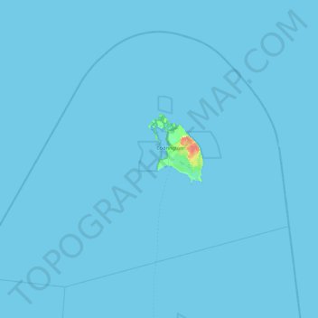
Name: Barbuda topographic map, elevation, terrain.
Location: Barbuda, Antigua and Barbuda (17.27198 -62.37657 17.94730 -61.49462)
Average elevation: 0 m
Minimum elevation: -1 m
Maximum elevation: 41 m
Make a donation
Gear up for your next adventure:
As an Amazon Associate, this site earns from qualifying purchases at no extra cost to you.