
Make a donation
Gear up for your next adventure:
As an Amazon Associate, this site earns from qualifying purchases at no extra cost to you.
Jatara topographic map
Click on the map to display elevation.
Make a donation
Gear up for your next adventure:
As an Amazon Associate, this site earns from qualifying purchases at no extra cost to you.
Jatara
Jatara is located at 25°01′N 79°03′E / 25.02°N 79.05°E / 25.02; 79.05. It has an average elevation of 246 metres (807 feet).it is situated near Khajuraho and Orchha.
Make a donation
Gear up for your next adventure:
As an Amazon Associate, this site earns from qualifying purchases at no extra cost to you.
About this map
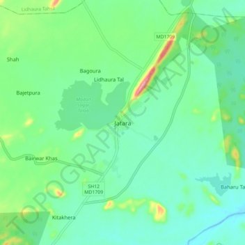
Name: Jatara topographic map, elevation, terrain.
Location: Jatara, Jatara Tahsil, Tikamgarh, Madhya Pradesh, India (24.96945 79.00851 25.04945 79.08851)
Average elevation: 260 m
Minimum elevation: 225 m
Maximum elevation: 366 m
Make a donation
Gear up for your next adventure:
As an Amazon Associate, this site earns from qualifying purchases at no extra cost to you.