
Boise topographic map
Click on the map to display elevation.
Boise
Boise (locally /ˈbɔɪsi/ BOY-see, also /bɔɪzi/ BOY-zee) is the capital and most populous city in the U.S. state of Idaho and is the county seat of Ada County. As of the 2020 census, there were 235,684 people residing in the city. On the Boise River in southwestern Idaho, it is 41 miles (66 km) east of the Oregon border and 110 miles (177 km) north of the Nevada border. The downtown area's elevation is 2,704 feet (824 m) above sea level.
About this map
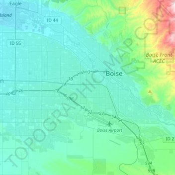
Name: Boise topographic map, elevation, terrain.
Location: Boise, Ada County, Idaho, United States (43.50940 -116.36568 43.69206 -116.09419)
Average elevation: 974 m
Minimum elevation: 779 m
Maximum elevation: 1,951 m