
Make a donation
Gear up for your next adventure:
As an Amazon Associate, this site earns from qualifying purchases at no extra cost to you.
Middle castle topographic map
Click on the map to display elevation.
Make a donation
Gear up for your next adventure:
As an Amazon Associate, this site earns from qualifying purchases at no extra cost to you.
About this map
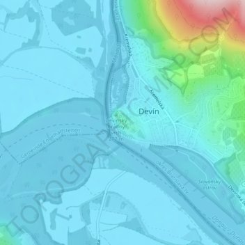
Name: Middle castle topographic map, elevation, terrain.
Average elevation: 171 m
Minimum elevation: 137 m
Maximum elevation: 456 m
Make a donation
Gear up for your next adventure:
As an Amazon Associate, this site earns from qualifying purchases at no extra cost to you.
Other topographic maps
Click on a map to view its topography, its elevation and its terrain.
Make a donation
Gear up for your next adventure:
As an Amazon Associate, this site earns from qualifying purchases at no extra cost to you.
Devínska Nová Ves
Slovakia > Region of Bratislava > Bratislava
The municipality lies at an altitude of 159 metres (522 ft) and covers an area of 24.21 km2 (9.35 sq mi) (2024).
Average elevation: 168 m