
Make a donation
Gear up for your next adventure:
As an Amazon Associate, this site earns from qualifying purchases at no extra cost to you.
Valencia topographic map
Click on the map to display elevation.
Make a donation
Gear up for your next adventure:
As an Amazon Associate, this site earns from qualifying purchases at no extra cost to you.
About this map
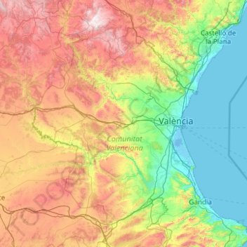
Name: Valencia topographic map, elevation, terrain.
Location: Valencia, Valencianische Gemeinschaft, Spanien (38.68655 -1.52894 40.21168 -0.02472)
Average elevation: 570 m
Minimum elevation: -4 m
Maximum elevation: 1,996 m
Make a donation
Gear up for your next adventure:
As an Amazon Associate, this site earns from qualifying purchases at no extra cost to you.
Other topographic maps
Click on a map to view its topography, its elevation and its terrain.
Urbanización Doña Pepa
Spanien > Valencianische Gemeinschaft > el Baix Segura / La Vega Baja del Segura > Rojales
Average elevation: 24 m
Urbanización Mas de la Montañeta
Spanien > Valencianische Gemeinschaft > Torrent
Average elevation: 70 m