
Make a donation
Gear up for your next adventure:
As an Amazon Associate, this site earns from qualifying purchases at no extra cost to you.
Pfafflar topographic map
Click on the map to display elevation.
Make a donation
Gear up for your next adventure:
As an Amazon Associate, this site earns from qualifying purchases at no extra cost to you.
Pfafflar
Die Siedler rodeten Wald, um Wiesen für Viehzucht (Ziegen, Schafe, Kühe) und Ackerbau (Kartoffeln, Getreide, Flachs und Bohnen) zu bekommen. Somit waren sie wirtschaftlich unabhängig. Damals war das Leben in den Bergen ein harter Überlebenskampf. Die Bergwiesen wurden zum Teil bis auf 2.300 m Höhe gemäht, um Heu für das Vieh im Winter zu haben. Einige mündliche Überlieferungen besagen, dass oberhalb vom Ortsteil Boden, am Fuße des Rotkopfes, Bergbau betrieben wurde. Abgebaut wurde Galmei und Blei. Davon zeugt noch heute ein kleiner Bergstollen unterhalb des Rotkopfes.
Make a donation
Gear up for your next adventure:
As an Amazon Associate, this site earns from qualifying purchases at no extra cost to you.
About this map
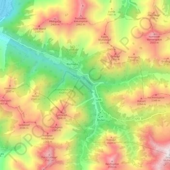
Name: Pfafflar topographic map, elevation, terrain.
Location: Pfafflar, Bezirk Reutte, Tirol, 6647, Österreich (47.26748 10.54124 47.33169 10.65690)
Average elevation: 1,814 m
Minimum elevation: 969 m
Maximum elevation: 2,751 m
Make a donation
Gear up for your next adventure:
As an Amazon Associate, this site earns from qualifying purchases at no extra cost to you.
Other topographic maps
Click on a map to view its topography, its elevation and its terrain.
Make a donation
Gear up for your next adventure:
As an Amazon Associate, this site earns from qualifying purchases at no extra cost to you.
Weißenbach am Lech
Österreich > Tirol > Bezirk Reutte > Gemeinde Weißenbach am Lech
Average elevation: 1,047 m
Make a donation
Gear up for your next adventure:
As an Amazon Associate, this site earns from qualifying purchases at no extra cost to you.
Gessebach
Österreich > Tirol > Bezirk Reutte > Gemeinde Nesselwängle > Haller
Average elevation: 1,362 m
Geierköpfe-Ostgipfel
Österreich > Tirol > Bezirk Reutte > Marktgemeinde Reutte
Der Aufstieg vom Plansee weist wegen der Verluste über 1200 Höhenmeter auf und dauert drei bis vier Stunden. Es handelt sich um eine leichte Bergtour, bei der man nur an einer einzigen Stelle kurz vor dem Gipfel auch Hand anlegen muss.
Average elevation: 1,590 m
Make a donation
Gear up for your next adventure:
As an Amazon Associate, this site earns from qualifying purchases at no extra cost to you.