
Make a donation
Gear up for your next adventure:
As an Amazon Associate, this site earns from qualifying purchases at no extra cost to you.
Winkl topographic map
Click on the map to display elevation.
Make a donation
Gear up for your next adventure:
As an Amazon Associate, this site earns from qualifying purchases at no extra cost to you.
About this map
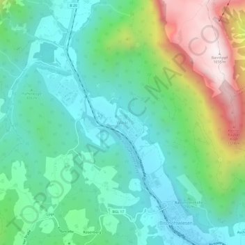
Name: Winkl topographic map, elevation, terrain.
Average elevation: 900 m
Minimum elevation: 609 m
Maximum elevation: 1,638 m
Make a donation
Gear up for your next adventure:
As an Amazon Associate, this site earns from qualifying purchases at no extra cost to you.
Other topographic maps
Click on a map to view its topography, its elevation and its terrain.
Watzmann
Germany > Bavaria > Landkreis Berchtesgadener Land > Ramsau bei Berchtesgaden
Average elevation: 1,177 m
Hintersee
Germany > Bavaria > Landkreis Berchtesgadener Land > Ramsau bei Berchtesgaden
Average elevation: 1,005 m
Nationalpark Berchtesgaden
Germany > Bavaria > Landkreis Berchtesgadener Land
Average elevation: 1,431 m
Make a donation
Gear up for your next adventure:
As an Amazon Associate, this site earns from qualifying purchases at no extra cost to you.