Geolocate

Bhimashankar topographic map

Click on the map to display elevation.

About this map
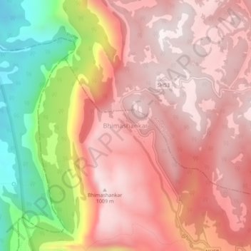
Name: Bhimashankar topographic map, elevation, terrain.

Location: Bhimashankar, Khed, Pune District, Maharashtra, India (19.05200 73.51576 19.09200 73.55576)

Average elevation: 749 m

Minimum elevation: 165 m

Maximum elevation: 1,047 m

Other topographic maps

Click on a map to view its topography, its elevation and its terrain.
Chaskaman

India > Maharashtra > Khed

Average elevation: 669 m

Gear up for your next adventure:

🌧️Rain Jackets - Waterproof jackets for hiking
📖Australian Bush Survival Books - Local knowledge on finding water and surviving the outback
🧦Merino Wool Hiking Socks - Moisture-wicking socks to prevent blisters during long topographic surveys
🥾Heavy Duty Hiking Boots - Ankle-supporting boots for carrying heavy packs on steep contours
📣High-Decibel Survival Whistles - Signaling tool for rescue that carries much further than a human voice

As an Amazon Associate, this site earns from qualifying purchases at no extra cost to you.