
Make a donation
Gear up for your next adventure:
As an Amazon Associate, this site earns from qualifying purchases at no extra cost to you.
Zakynthos topographic map
Click on the map to display elevation.
Make a donation
Gear up for your next adventure:
As an Amazon Associate, this site earns from qualifying purchases at no extra cost to you.
About this map
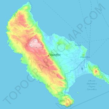
Name: Zakynthos topographic map, elevation, terrain.
Average elevation: 82 m
Minimum elevation: -3 m
Maximum elevation: 749 m
Make a donation
Gear up for your next adventure:
As an Amazon Associate, this site earns from qualifying purchases at no extra cost to you.
Other topographic maps
Click on a map to view its topography, its elevation and its terrain.
Gargaliani
Greece > Peloponnese, Western Greece and the Ionian > Messenia Regional Unit > Gargalianoi Municipal Unit
Average elevation: 193 m
Nafplio
Greece > Peloponnese, Western Greece and the Ionian > Argolis Regional Unit > Municipal Unit of Nafplio
Average elevation: 36 m
Stoupa
Greece > Peloponnese, Western Greece and the Ionian > Messenia Regional Unit > Municipal Unit of Lefktro
Average elevation: 63 m
Kalogria Beach
Greece > Peloponnese, Western Greece and the Ionian > Achaia Regional Unit > Municipal Unit of Larissos
Average elevation: 1 m
Make a donation
Gear up for your next adventure:
As an Amazon Associate, this site earns from qualifying purchases at no extra cost to you.
Βαρθολομιό
Greece > Peloponnese, Western Greece and the Ionian > Elis Regional Unit
Average elevation: 24 m
Stelari Beach
Greece > Peloponnese, Western Greece and the Ionian > Corfu Regional Unit
Average elevation: 118 m
Mitikas
Greece > Peloponnese, Western Greece and the Ionian > Aetolia-Acarnania Regional Unit > Municipal Unit of Alyzia
Average elevation: 27 m
Kefalonia
Greece > Peloponnese, Western Greece and the Ionian > Kefallonia Regional Unit
Average elevation: 60 m
Make a donation
Gear up for your next adventure:
As an Amazon Associate, this site earns from qualifying purchases at no extra cost to you.
Katastari
Greece > Peloponnese, Western Greece and the Ionian > Zakynthos Regional Unit > Katastari
Average elevation: 165 m
Alikes
Greece > Peloponnese, Western Greece and the Ionian > Zakynthos Regional Unit > Alykanas
Average elevation: 33 m