
Make a donation
Gear up for your next adventure:
As an Amazon Associate, this site earns from qualifying purchases at no extra cost to you.
Derby topographic map
Click on the map to display elevation.
Make a donation
Gear up for your next adventure:
As an Amazon Associate, this site earns from qualifying purchases at no extra cost to you.
About this map
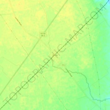
Name: Derby topographic map, elevation, terrain.
Location: Derby, Pickaway County, Ohio, 43117, United States (39.74867 -83.22575 39.78867 -83.18575)
Average elevation: 278 m
Minimum elevation: 263 m
Maximum elevation: 284 m
Make a donation
Gear up for your next adventure:
As an Amazon Associate, this site earns from qualifying purchases at no extra cost to you.
Other topographic maps
Click on a map to view its topography, its elevation and its terrain.
Ashville
United States > Ohio > Pickaway County
Ashville is located in the Scioto River Valley and has an elevation of 715 feet (218 m) above sea level. The village is located in the till plain-area of Western Ohio and borders the Appalachian Plateau. The area is generally viewed to be a fertile region with gently rolling hills created by moraines.
Average elevation: 216 m
Make a donation
Gear up for your next adventure:
As an Amazon Associate, this site earns from qualifying purchases at no extra cost to you.
Tarlton
United States > Ohio > Pickaway County
Tarlton's elevation is 902 feet above sea level.
Average elevation: 287 m
Make a donation
Gear up for your next adventure:
As an Amazon Associate, this site earns from qualifying purchases at no extra cost to you.