Geolocate

Wedge Island topographic map

Click on the map to display elevation.

About this map

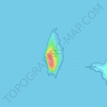
Name: Wedge Island topographic map, elevation, terrain.

Location: Wedge Island, Tasman, Tasmania, Australia (-43.14134 147.66910 -43.12922 147.67531)

Average elevation: 2 m

Minimum elevation: 0 m

Maximum elevation: 91 m

Tasmania trails, hiking, mountain biking, running and outdoor activities

Other topographic maps

Click on a map to view its topography, its elevation and its terrain.

Cape Pillar

Australia > Tasmania > Tasman

Average elevation: 18 m

Tasman Island

Australia > Tasmania > Tasman

Average elevation: 19 m

Simmonds Hill

Australia > Tasmania > Tasman

Average elevation: 189 m

White Beach

Australia > Tasmania > Tasman > White Beach

Average elevation: 45 m

Gear up for your next adventure:

🛠️Outdoor Repair Kits - Gear repair kits
🔦LED Torches - LED torches for outdoor use
📦Crushproof Equipment Cases - Safe transport for sensitive surveying and mapping instruments
📡Portable Emergency Radios - Stay informed about weather warnings and bushfire alerts
🕯️Emergency Whistles - Safety whistles for hiking

As an Amazon Associate, this site earns from qualifying purchases at no extra cost to you.