
Ploërmel topographic map
Interactive map
Click on the map to display elevation.
About this map
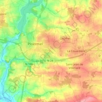
Name: Ploërmel topographic map, elevation, terrain.
Average elevation: 72 m
Minimum elevation: 20 m
Maximum elevation: 127 m
Other topographic maps
Click on a map to view its topography, its elevation and its terrain.
Monterrein
Monterrein, Ploërmel, Pontivy, Morbihan, Bretagne, France métropolitaine, 56800, France
Average elevation: 93 m