
Make a donation
Gear up for your next adventure:
As an Amazon Associate, this site earns from qualifying purchases at no extra cost to you.
Chiniguchi River topographic map
Click on the map to display elevation.
Make a donation
Gear up for your next adventure:
As an Amazon Associate, this site earns from qualifying purchases at no extra cost to you.
About this map
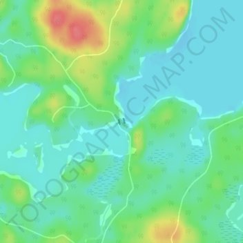
Name: Chiniguchi River topographic map, elevation, terrain.
Average elevation: 260 m
Minimum elevation: 241 m
Maximum elevation: 308 m
Make a donation
Gear up for your next adventure:
As an Amazon Associate, this site earns from qualifying purchases at no extra cost to you.
Other topographic maps
Click on a map to view its topography, its elevation and its terrain.
Spanish Chutes
Canada > Ontario > Sudbury District > Unorganized North Sudbury
Average elevation: 425 m
Ishpatina Ridge Fire Tower
Canada > Ontario > Sudbury District > Unorganized North Sudbury
Average elevation: 545 m
Tatachikapika Lake
Canada > Ontario > Sudbury District > Unorganized North Sudbury
Average elevation: 385 m
Make a donation
Gear up for your next adventure:
As an Amazon Associate, this site earns from qualifying purchases at no extra cost to you.
Mattagami Lake
Canada > Ontario > Sudbury District > Unorganized North Sudbury > Mattagami
Average elevation: 368 m
Nepewassi Lake
Canada > Ontario > Sudbury District > Unorganized North Sudbury
Average elevation: 223 m
Make a donation
Gear up for your next adventure:
As an Amazon Associate, this site earns from qualifying purchases at no extra cost to you.
Whitefish Falls
Canada > Ontario > Sudbury District > Unorganized North Sudbury
Average elevation: 205 m
McLennan Creek;Moodie Lake
Canada > Ontario > Sudbury District > Unorganized North Sudbury
Average elevation: 456 m
Spanish River Provincial Park
Canada > Ontario > Sudbury District > Unorganized North Sudbury
Average elevation: 410 m
Make a donation
Gear up for your next adventure:
As an Amazon Associate, this site earns from qualifying purchases at no extra cost to you.
Willisville
Canada > Ontario > Sudbury District > Unorganized North Sudbury > Whitefish Falls
Average elevation: 219 m
West Shining Tree Lake
Canada > Ontario > Sudbury District > Unorganized North Sudbury > Shining Tree
Average elevation: 380 m
Make a donation
Gear up for your next adventure:
As an Amazon Associate, this site earns from qualifying purchases at no extra cost to you.
Ministic Lake
Canada > Ontario > Sudbury District > Unorganized North Sudbury
Average elevation: 384 m
Halfway Lake Provincial Park
Canada > Ontario > Sudbury District > Unorganized North Sudbury
Average elevation: 440 m
Dividing Lake
Canada > Ontario > Sudbury District > Unorganized North Sudbury
Average elevation: 391 m
Make a donation
Gear up for your next adventure:
As an Amazon Associate, this site earns from qualifying purchases at no extra cost to you.
Low Water Lake
Canada > Ontario > Sudbury District > Unorganized North Sudbury
Average elevation: 427 m
Make a donation
Gear up for your next adventure:
As an Amazon Associate, this site earns from qualifying purchases at no extra cost to you.