
Rodalbe topographic map
Interactive map
Click on the map to display elevation.
About this map
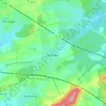
Name: Rodalbe topographic map, elevation, terrain.
Average elevation: 258 m
Minimum elevation: 227 m
Maximum elevation: 349 m
Other topographic maps
Click on a map to view its topography, its elevation and its terrain.
Chemin de Pierres
France > Grand Est > Moselle > Rodalbe
Chemin de Pierres, Rodalbe, Sarrebourg-Château-Salins, Moselle, Grand Est, France métropolitaine, 57340, France
Average elevation: 259 m