
Make a donation
Gear up for your next adventure:
As an Amazon Associate, this site earns from qualifying purchases at no extra cost to you.
North Pacific topographic map
Click on the map to display elevation.
Make a donation
Gear up for your next adventure:
As an Amazon Associate, this site earns from qualifying purchases at no extra cost to you.
About this map
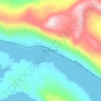
Name: North Pacific topographic map, elevation, terrain.
Average elevation: 240 m
Minimum elevation: -1 m
Maximum elevation: 763 m
Make a donation
Gear up for your next adventure:
As an Amazon Associate, this site earns from qualifying purchases at no extra cost to you.
Other topographic maps
Click on a map to view its topography, its elevation and its terrain.
Ducie Island
Canada > British Columbia > North Coast Regional District > Area A (North Skeena)
Average elevation: 1 m
Lelu Island
Canada > British Columbia > North Coast Regional District > Port Edward
Average elevation: 23 m
Ness Islands
Canada > British Columbia > North Coast Regional District > Area C (South Skeena)
Average elevation: 1 m
Make a donation
Gear up for your next adventure:
As an Amazon Associate, this site earns from qualifying purchases at no extra cost to you.
K'Mooda/Lowe-Gamble Conservancy
Canada > British Columbia > North Coast Regional District > Area C (South Skeena)
Average elevation: 251 m
Dolphin Island
Canada > British Columbia > North Coast Regional District > Area C (South Skeena) > Kitkatla
Average elevation: 19 m
Zayas Island
Canada > British Columbia > North Coast Regional District > Area A (North Skeena)
Average elevation: 7 m
Make a donation
Gear up for your next adventure:
As an Amazon Associate, this site earns from qualifying purchases at no extra cost to you.