
Tirap topographic map
Interactive map
Click on the map to display elevation.
About this map
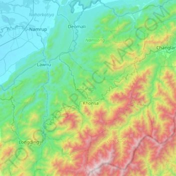
Name: Tirap topographic map, elevation, terrain.
Location: Tirap, Arunachal Pradesh, India (26.79515 95.36104 27.26562 95.69166)
Average elevation: 784 m
Minimum elevation: 109 m
Maximum elevation: 2,752 m
Tirap district occupies an area of 2,362 square kilometres (912 sq mi), comparatively equivalent to Canada's Cornwall Island. The elevation ranges from 200 meters in the northwest to 4,000 meters in the Patkai Hills. After bifurcation the district occupied an area of 1,170 square km.
Other topographic maps
Click on a map to view its topography, its elevation and its terrain.
Tallong
India > Arunachal Pradesh > Bameng ADC > Tallong
Tallong, Bameng ADC, East Kameng, Arunachal Pradesh, India
Average elevation: 773 m
Tawang
India > Arunachal Pradesh > Tawang
Tawang, Tawang district, Arunachal Pradesh, India
Average elevation: 2,891 m