
Lac-Brome topographic map
Interactive map
Click on the map to display elevation.
About this map
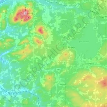
Name: Lac-Brome topographic map, elevation, terrain.
Location: Lac-Brome, Brome-Missisquoi, Estrie, Quebec, Canada (45.15754 -72.69041 45.30751 -72.47821)
Average elevation: 264 m
Minimum elevation: 138 m
Maximum elevation: 674 m
Other topographic maps
Click on a map to view its topography, its elevation and its terrain.
Brigham
Canada > Quebec > Brome-Missisquoi
Brigham, Brome-Missisquoi, Estrie, Quebec, J2K 4V6, Canada
Average elevation: 96 m
West Brome
Canada > Quebec > Brome-Missisquoi > Lac-Brome
West Brome, Lac-Brome, Brome-Missisquoi, Estrie, Quebec, J0E 2P0, Canada
Average elevation: 162 m
Mystic
Canada > Quebec > Brome-Missisquoi > Saint-Ignace-de-Stanbridge
Mystic, Saint-Ignace-de-Stanbridge, Brome-Missisquoi, Estrie, Quebec, J0J 1Y0, Canada
Average elevation: 60 m
Mont Brome
Canada > Quebec > Brome-Missisquoi > Bromont
Mont Brome, Bromont, Brome-Missisquoi, Estrie, Quebec, J2L 2K7, Canada
Average elevation: 331 m
Sutton
Canada > Quebec > Brome-Missisquoi > Sutton
Sutton, Brome-Missisquoi, Estrie, Quebec, Canada
Average elevation: 297 m