
Distrito David topographic map
Interactive map
Click on the map to display elevation.
About this map
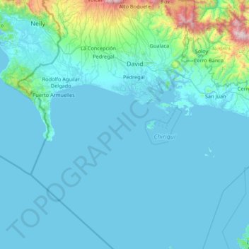
Name: Distrito David topographic map, elevation, terrain.
Location: Distrito David, Chiriquí, Panamá (7.46329 -82.55959 8.77027 -82.20538)
Average elevation: 156 m
Minimum elevation: -1 m
Maximum elevation: 2,478 m
Es un distrito de segundo orden de división administrativa (class A - Región Administrativa) ubicado en la Provincia de Chiriquí, Panamá (Norte América) con un código de región de Américas/Western Europe. Se encuentra a una altitud de 8 metros sobre el nivel del mar.
Other topographic maps
Click on a map to view its topography, its elevation and its terrain.
Hacienda Los Molinos
Panamá > Chiriquí > Distrito Boquete > Alto Boquete
Hacienda Los Molinos, Alto Boquete, Distrito Boquete, Chiriquí, Panamá
Average elevation: 660 m
Distrito San Félix
Panamá > Chiriquí > Distrito San Félix
Distrito San Félix, Chiriquí, Panamá
Average elevation: 52 m
Potrerillos
Panamá > Chiriquí > Distrito Dolega > Potrerillos
Potrerillos, Distrito Dolega, Chiriquí, Panamá
Average elevation: 1,113 m
San Pablo Nuevo
Panamá > Chiriquí > San Pablo Nuevo
San Pablo Nuevo, Distrito David, Chiriquí, Panamá
Average elevation: 26 m