
Grad Senj topographic map
Interactive map
Click on the map to display elevation.
About this map
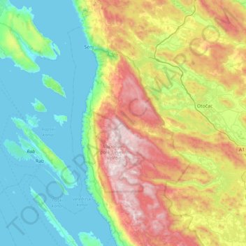
Name: Grad Senj topographic map, elevation, terrain.
Location: Grad Senj, Comitat de Lika-Senj, Croatie (44.58205 14.87882 45.08373 15.12441)
Average elevation: 494 m
Minimum elevation: -1 m
Maximum elevation: 1,645 m
Other topographic maps
Click on a map to view its topography, its elevation and its terrain.
Volarice
Croatie > Comitat de Lika-Senj
Volarice, Grad Senj, Comitat de Lika-Senj, Croatie
Average elevation: 801 m
Grad Novalja
Croatie > Comitat de Lika-Senj
Grad Novalja, Comitat de Lika-Senj, Croatie
Average elevation: 206 m
Jošani
Croatie > Comitat de Lika-Senj
Jošani, Općina Udbina, Comitat de Lika-Senj, Croatie
Average elevation: 844 m
Baške Oštarije
Croatie > Comitat de Lika-Senj
Baške Oštarije, Općina Karlobag, Comitat de Lika-Senj, Croatie
Average elevation: 992 m
Pavlinov rt
Croatie > Comitat de Lika-Senj > Plitvička Jezera
Pavlinov rt, Plitvička Jezera, Općina Plitvička Jezera, Comitat de Lika-Senj, 53231, Croatie
Average elevation: 642 m
Plitvica Selo
Croatie > Comitat de Lika-Senj
Plitvica Selo, Općina Plitvička Jezera, Comitat de Lika-Senj, 53231, Croatie
Average elevation: 639 m
Vrelo Koreničko
Croatie > Comitat de Lika-Senj > Vrelo Koreničko
Vrelo Koreničko, Općina Plitvička Jezera, Comitat de Lika-Senj, 53230, Croatie
Average elevation: 818 m
Jezerce
Croatie > Comitat de Lika-Senj
Jezerce, Općina Plitvička Jezera, Comitat de Lika-Senj, 53231, Croatie
Average elevation: 685 m
Novalja
Croatie > Comitat de Lika-Senj > Novalja
Novalja, Grad Novalja, Comitat de Lika-Senj, 53291, Croatie
Average elevation: 33 m