
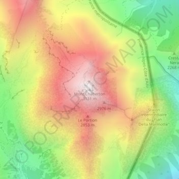
Mont Chaberton topographic map
Interactive map
Click on the map to display elevation.
About this map
Name: Mont Chaberton topographic map, elevation, terrain.
Average elevation: 2,436 m
Minimum elevation: 1,731 m
Maximum elevation: 3,120 m
Le mont Chaberton est un sommet des Alpes françaises dans le massif des Cerces et précisément dans le chaînon du Chaberton, dans le département des Hautes-Alpes. Il culmine à 3 131 m d'altitude.
Other topographic maps
Click on a map to view its topography, its elevation and its terrain.
Le Chenaillet
France > Provence-Alpes-Côte d'Azur > Montgenèvre
Le Chenaillet, Montgenèvre, Briançon, Hautes-Alpes, Provence-Alpes-Côte d'Azur, France métropolitaine, 05100, France
Average elevation: 2,324 m