
Florina topographic map
Interactive map
Click on the map to display elevation.
About this map
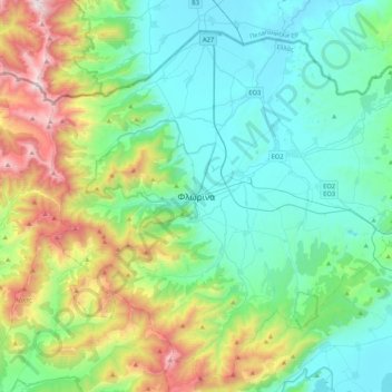
Name: Florina topographic map, elevation, terrain.
Average elevation: 999 m
Minimum elevation: 574 m
Maximum elevation: 2,319 m
Florina is one of the coldest towns in Greece, because of its elevation and geographic position. Snowfalls, sometimes heavy, thick fog and below-freezing temperatures are common during the winter months, while the summers are warm to hot. Under the Köppen climate classification, Florina has a humid subtropical climate (Cfa), bordering on a humid continental climate (Dfa).