
Kyūshū topographic map
Interactive map
Click on the map to display elevation.
Kyūshū
The total area is 36,782.37 km2 (14,201.75 sq mi) which makes it the 37th largest island in the world. It's slightly larger than Taiwan island 35,808 km2 (13,826 sq mi). The highest elevation is 1791 meters (5876 feet) on Mount Kujū.
About this map
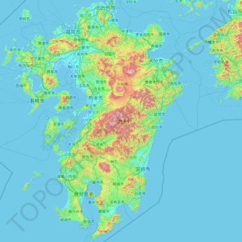
Name: Kyūshū topographic map, elevation, terrain.
Location: Kyūshū, Japan (30.99434 129.55222 33.96988 132.08533)
Average elevation: 116 m
Minimum elevation: -4 m
Maximum elevation: 1,741 m
Other topographic maps
Click on a map to view its topography, its elevation and its terrain.
東京湾
The shoal between Cape Futtsu in Chiba Prefecture and Cape Honmaku in Yokohama is known as Nakanose, and has a depth of 20 metres (66 ft). North of this area the bay has a depth of 40 metres (130 ft) and an uncomplicated underwater topography. Areas south of Nakanose are significantly deeper moving towards the…
Average elevation: 0 m