
Make a donation
Gear up for your next adventure:
As an Amazon Associate, this site earns from qualifying purchases at no extra cost to you.
Nantwich topographic map
Click on the map to display elevation.
Make a donation
Gear up for your next adventure:
As an Amazon Associate, this site earns from qualifying purchases at no extra cost to you.
About this map
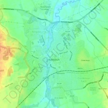
Name: Nantwich topographic map, elevation, terrain.
Location: Nantwich, Cheshire East, England, United Kingdom (53.05219 -2.54047 53.08552 -2.49598)
Average elevation: 45 m
Minimum elevation: 31 m
Maximum elevation: 66 m
Make a donation
Gear up for your next adventure:
As an Amazon Associate, this site earns from qualifying purchases at no extra cost to you.
Other topographic maps
Click on a map to view its topography, its elevation and its terrain.
Bickerton Hill
United Kingdom > England > Cheshire East > Bickerton
Bickerton Hill refers to two low red sandstone hills that form the southern end of the Mid Cheshire Ridge in Cheshire, north-west England. The high point, Raw Head, lies on the northerly hill and has an elevation of 227 metres. Parts of the southerly hill are also known as Larkton Hill.
Average elevation: 134 m
Smith's Green
United Kingdom > England > Cheshire East > Barthomley > Smith's Green
Average elevation: 80 m
Make a donation
Gear up for your next adventure:
As an Amazon Associate, this site earns from qualifying purchases at no extra cost to you.