
Municipality of Vyronas topographic map
Interactive map
Click on the map to display elevation.
About this map
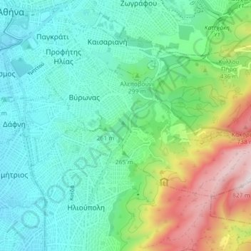
Name: Municipality of Vyronas topographic map, elevation, terrain.
Average elevation: 275 m
Minimum elevation: 69 m
Maximum elevation: 850 m
Other topographic maps
Click on a map to view its topography, its elevation and its terrain.
Athens
Greece > Attica > Regional Unit of Central Athens
Athens, Municipality of Athens, Regional Unit of Central Athens, Attica, 105 57, Greece
Average elevation: 168 m
Municipality of Dafni - Ymittos
Greece > Attica > Regional Unit of Central Athens
Municipality of Dafni - Ymittos, Regional Unit of Central Athens, Attica, Greece
Average elevation: 128 m