
Guildford topographic map
Click on the map to display elevation.
About this map
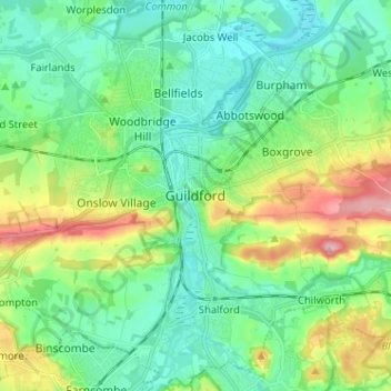
Name: Guildford topographic map, elevation, terrain.
Location: Guildford, Surrey, England, GU1 3DP, United Kingdom (51.19561 -0.61321 51.27561 -0.53321)
Average elevation: 64 m
Minimum elevation: 22 m
Maximum elevation: 171 m
Other topographic maps
Click on a map to view its topography, its elevation and its terrain.
Shalford
United Kingdom > England > Surrey > Guildford > Guildford
Lt.Col. Henry Haversham Godwin-Austen (1834–1923), topographer, geologist, naturalist and explorer who surveyed the Himalayan region, including K2, sometimes known as Mt. Godwin-Austen, for a time had an estate in Shalford.
Average elevation: 54 m
Cranleigh Waters or Bramley Wey
United Kingdom > England > Surrey > Guildford > Shalford
Average elevation: 52 m