
Mans topographic map
Interactive map
Click on the map to display elevation.
About this map
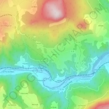
Name: Mans topographic map, elevation, terrain.
Average elevation: 719 m
Minimum elevation: 505 m
Maximum elevation: 1,067 m
Other topographic maps
Click on a map to view its topography, its elevation and its terrain.
43810
France > Auvergne-Rhône-Alpes > Haute-Loire > Roche-en-Régnier > Poussac
Average elevation: 831 m