
Thank you for supporting this site ❤️
Make a donation
Make a donation
Gear up for your next adventure:
As an Amazon Associate, this site earns from qualifying purchases at no extra cost to you.
Tivaouane topographic map
Click on the map to display elevation.
Thank you for supporting this site ❤️
Make a donation
Make a donation
Gear up for your next adventure:
As an Amazon Associate, this site earns from qualifying purchases at no extra cost to you.
About this map
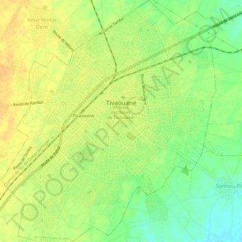
Name: Tivaouane topographic map, elevation, terrain.
Location: Tivaouane, Département de Tivaouane, Thiès Region, Senegal (14.92391 -16.83760 14.97185 -16.79274)
Average elevation: 53 m
Minimum elevation: 36 m
Maximum elevation: 64 m
Thank you for supporting this site ❤️
Make a donation
Make a donation
Gear up for your next adventure:
As an Amazon Associate, this site earns from qualifying purchases at no extra cost to you.