
Azrou topographic map
Interactive map
Click on the map to display elevation.
About this map
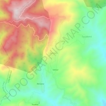
Name: Azrou topographic map, elevation, terrain.
Location: Azrou, Colla, Daïra Djaafra, Bordj Bou Arreridj, Algérie (36.23477 4.63463 36.27477 4.67463)
Average elevation: 1,025 m
Minimum elevation: 741 m
Maximum elevation: 1,380 m
Other topographic maps
Click on a map to view its topography, its elevation and its terrain.
Colla
Algérie > Bordj Bou Arreridj > Daïra Djaafra
Colla, Daïra Djaafra, Bordj Bou Arreridj, Algérie
Average elevation: 965 m