
Hohenhengstenberg topographic map
Interactive map
Click on the map to display elevation.
About this map
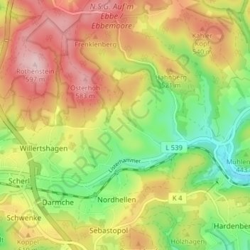
Name: Hohenhengstenberg topographic map, elevation, terrain.
Average elevation: 488 m
Minimum elevation: 378 m
Maximum elevation: 600 m
Other topographic maps
Click on a map to view its topography, its elevation and its terrain.
Hesselbecke
Deutschland > Nordrhein-Westfalen > Märkischer Kreis > Meinerzhagen > Nordhellen
Hesselbecke, Nordhellen, Meinerzhagen, Märkischer Kreis, Nordrhein-Westfalen, 58540, Deutschland
Average elevation: 478 m