
Provincia de Cantón topographic map
Interactive map
Click on the map to display elevation.
About this map
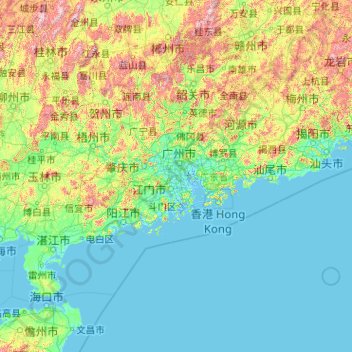
Name: Provincia de Cantón topographic map, elevation, terrain.
Location: Provincia de Cantón, China (20.11981 109.44948 25.51952 117.66436)
Average elevation: 194 m
Minimum elevation: -4 m
Maximum elevation: 2,010 m
Other topographic maps
Click on a map to view its topography, its elevation and its terrain.
Conghua
Conghua, Cantón, Provincia de Cantón, China
Average elevation: 217 m
博罗县
China > Provincia de Cantón > 博罗县 > Huizhou
博罗县, Huizhou, Provincia de Cantón, China
Average elevation: 134 m
佛山市
China > Provincia de Cantón > 佛山市
佛山市, 禅城区 (Chancheng), 佛山市, Provincia de Cantón, 528000, China
Average elevation: 8 m