
Tarragone topographic map
Interactive map
Click on the map to display elevation.
About this map
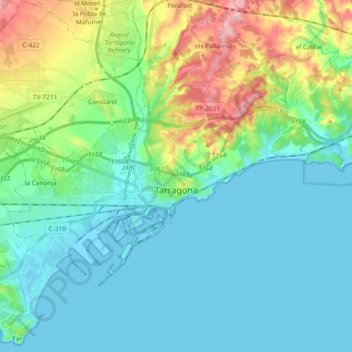
Name: Tarragone topographic map, elevation, terrain.
Location: Tarragone, Tarragonais, Tarragone, Catalogne, 43001, Espagne (41.07864 1.18706 41.16688 1.37523)
Average elevation: 41 m
Minimum elevation: -5 m
Maximum elevation: 177 m
Other topographic maps
Click on a map to view its topography, its elevation and its terrain.
la Secuita
Espagne > Catalogne > Tarragonais
la Secuita, Tarragonais, Tarragone, Catalogne, 43154, Espagne
Average elevation: 143 m
la Riera de Gaià
Espagne > Catalogne > Tarragonais
la Riera de Gaià, Tarragonais, Tarragone, Catalogne, 43762, Espagne
Average elevation: 53 m