
Make a donation
Gear up for your next adventure:
As an Amazon Associate, this site earns from qualifying purchases at no extra cost to you.
Norway topographic map
Click on the map to display elevation.
Make a donation
Gear up for your next adventure:
As an Amazon Associate, this site earns from qualifying purchases at no extra cost to you.
Norway
Norway's topography is defined by its rugged and varied terrain, shaped by ancient geological processes and glacial activity. Dominating the landscape are the Scandinavian Mountains, which run through the country and include peaks like Galdhøpiggen, the highest in Northern Europe at 2,469 meters (8,100 feet). These mountains descend sharply to the west, forming the dramatic fjords for which Norway is renowned, such as the Sognefjord, the world's second deepest fjord. In contrast, the eastern regions feature more gradual slopes leading to expansive valleys and plateaus. The Hardangervidda plateau, for instance, is Europe's largest mountain plateau, characterized by its barren, treeless moorlands and numerous lakes. Glacial erosion has left a significant mark on the terrain, carving out deep valleys and leaving behind numerous glaciers, especially in the western part of the country. This diverse and dramatic landscape not only defines Norway's natural beauty but also influences its climate, biodiversity, and human activities.
Make a donation
Gear up for your next adventure:
As an Amazon Associate, this site earns from qualifying purchases at no extra cost to you.
About this map
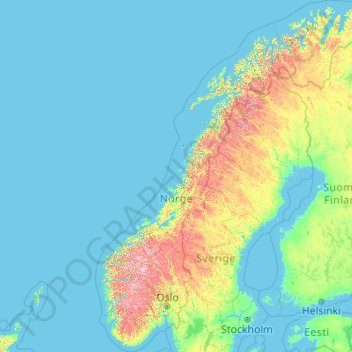
Name: Norway topographic map, elevation, terrain.
Location: Norway, Øvre Tveit, Apalen, Askøy, Hordaland, 5310, Norway (57.75901 4.08753 71.38488 31.76149)
Average elevation: 143 m
Minimum elevation: -3 m
Maximum elevation: 2,267 m
Make a donation
Gear up for your next adventure:
As an Amazon Associate, this site earns from qualifying purchases at no extra cost to you.