
Make a donation
Gear up for your next adventure:
As an Amazon Associate, this site earns from qualifying purchases at no extra cost to you.
Union City topographic map
Click on the map to display elevation.
Make a donation
Gear up for your next adventure:
As an Amazon Associate, this site earns from qualifying purchases at no extra cost to you.
About this map
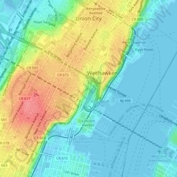
Name: Union City topographic map, elevation, terrain.
Location: Union City, Hudson County, New Jersey, 07087, United States (40.75061 -74.04586 40.78287 -74.01480)
Average elevation: 26 m
Minimum elevation: -4 m
Maximum elevation: 80 m
Make a donation
Gear up for your next adventure:
As an Amazon Associate, this site earns from qualifying purchases at no extra cost to you.
Other topographic maps
Click on a map to view its topography, its elevation and its terrain.
Croxton
United States > New Jersey > Hudson County > Jersey City > Journal Square
Average elevation: 16 m
Make a donation
Gear up for your next adventure:
As an Amazon Associate, this site earns from qualifying purchases at no extra cost to you.
North Hudson Park
United States > New Jersey > Hudson County > North Bergen > Hudson Heights
Average elevation: 41 m
Make a donation
Gear up for your next adventure:
As an Amazon Associate, this site earns from qualifying purchases at no extra cost to you.
Bergen Square
United States > New Jersey > Hudson County > Jersey City > Journal Square
Average elevation: 13 m
Marion
United States > New Jersey > Hudson County > Jersey City > Journal Square
Average elevation: 12 m
Make a donation
Gear up for your next adventure:
As an Amazon Associate, this site earns from qualifying purchases at no extra cost to you.
Croxton
United States > New Jersey > Hudson County > Jersey City > Journal Square
Average elevation: 16 m
Make a donation
Gear up for your next adventure:
As an Amazon Associate, this site earns from qualifying purchases at no extra cost to you.
Hudson River Waterfront
United States > New Jersey > Hudson County > Jersey City
Average elevation: 2 m
North End Business District
United States > New Jersey > Hudson County > Secaucus
Average elevation: 4 m
Bergen Square
United States > New Jersey > Hudson County > Jersey City > Journal Square
Average elevation: 13 m
Make a donation
Gear up for your next adventure:
As an Amazon Associate, this site earns from qualifying purchases at no extra cost to you.