Geolocate

Hartley topographic map

Click on the map to display elevation.

About this map

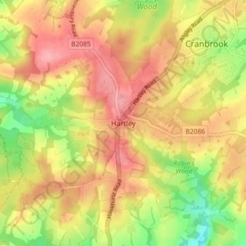
Name: Hartley topographic map, elevation, terrain.

Location: Hartley, Tunbridge Wells, Kent, South East England, England, TN17 3PX, United Kingdom (51.06358 0.49053 51.10358 0.53053)

Average elevation: 94 m

Minimum elevation: 35 m

Maximum elevation: 137 m

Other topographic maps

Click on a map to view its topography, its elevation and its terrain.

Gear up for your next adventure:

☀️Portable Solar Chargers - High-efficiency panels to hang on your backpack while walking
📟Satellite Messengers - Two-way satellite communication to stay in touch beyond the cellular grid
🥶Thermal Beanies - Warm hats for cold hikes
📱Shockproof Phone Cases - Extra protection for your smartphone against drops on rocky terrain
🎒Tactical Waist Packs - Quick access to your compass, phone, and snacks while walking

As an Amazon Associate, this site earns from qualifying purchases at no extra cost to you.