
Yayales topographic map
Interactive map
Click on the map to display elevation.
About this map
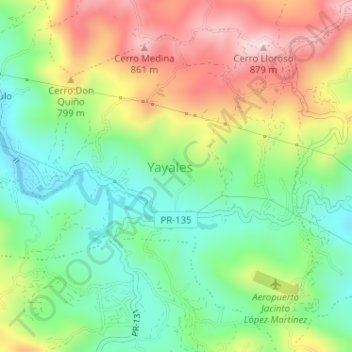
Name: Yayales topographic map, elevation, terrain.
Location: Yayales, Adjuntas, Puerto Rico, United States (18.17656 -66.78464 18.20221 -66.75263)
Average elevation: 667 m
Minimum elevation: 521 m
Maximum elevation: 875 m
Other topographic maps
Click on a map to view its topography, its elevation and its terrain.
Adjuntas
United States > Puerto Rico > Adjuntas
Adjuntas, Puerto Rico, 00601, United States
Average elevation: 688 m
Yahuecas
United States > Puerto Rico > Adjuntas
Yahuecas, Adjuntas, Puerto Rico, United States
Average elevation: 615 m