
Fafião topographic map
Interactive map
Click on the map to display elevation.
About this map
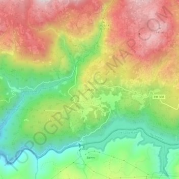
Name: Fafião topographic map, elevation, terrain.
Location: Fafião, Cabril, Montalegre, Vila Real, 4850-336, Portugal (41.68422 -8.10943 41.72422 -8.06943)
Average elevation: 488 m
Minimum elevation: 149 m
Maximum elevation: 875 m
Other topographic maps
Click on a map to view its topography, its elevation and its terrain.
Miradouro de Fafião
Portugal > Vila Real > Montalegre > Cabril > Fafião
Miradouro de Fafião, Rua da Portela do Monte, Fafião, Cabril, Montalegre, Vila Real, 4850-336, Portugal
Average elevation: 487 m
Lapela
Portugal > Vila Real > Montalegre > Cabril
Lapela, Cabril, Montalegre, Vila Real, Portugal
Average elevation: 714 m
Sete Lagoas
Portugal > Vila Real > Montalegre > Cabril
Sete Lagoas, Cabril, Montalegre, Vila Real, Portugal
Average elevation: 934 m
Poço da Corga de Pena Calva
Portugal > Vila Real > Montalegre > Cabril
Poço da Corga de Pena Calva, Cabril, Montalegre, Vila Real, Portugal
Average elevation: 1,090 m
Barragem do Ribeiro do Penedo
Portugal > Vila Real > Montalegre > Cabril
Barragem do Ribeiro do Penedo, Cabril, Montalegre, Vila Real, Portugal
Average elevation: 900 m
Minas dos Carris
Portugal > Vila Real > Montalegre > Cabril
Minas dos Carris, Cabril, Montalegre, Vila Real, Portugal
Average elevation: 1,349 m