
Thank you for supporting this site ❤️
Make a donation
Make a donation
Gear up for your next adventure:
As an Amazon Associate, this site earns from qualifying purchases at no extra cost to you.
Ouangani topographic map
Click on the map to display elevation.
Thank you for supporting this site ❤️
Make a donation
Make a donation
Gear up for your next adventure:
As an Amazon Associate, this site earns from qualifying purchases at no extra cost to you.
About this map
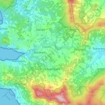
Name: Ouangani topographic map, elevation, terrain.
Location: Ouangani, Mayotte, 97670, France (-12.87423 45.12190 -12.80423 45.15479)
Average elevation: 166 m
Minimum elevation: 0 m
Maximum elevation: 555 m
Thank you for supporting this site ❤️
Make a donation
Make a donation
Gear up for your next adventure:
🧦Merino Wool Hiking Socks - Moisture-wicking socks to prevent blisters during long topographic surveys
As an Amazon Associate, this site earns from qualifying purchases at no extra cost to you.
Other topographic maps
Click on a map to view its topography, its elevation and its terrain.