
Thank you for supporting this site ❤️
Make a donation
Make a donation
Gear up for your next adventure:
🛰️Handheld GPS Units - Rugged GPS devices for tracking coordinates and elevation in the Australian bush
As an Amazon Associate, this site earns from qualifying purchases at no extra cost to you.
Dalkeith topographic map
Click on the map to display elevation.
Thank you for supporting this site ❤️
Make a donation
Make a donation
Gear up for your next adventure:
As an Amazon Associate, this site earns from qualifying purchases at no extra cost to you.
About this map
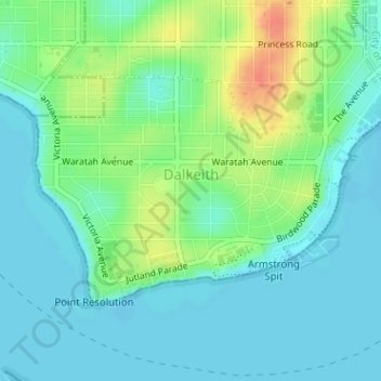
Name: Dalkeith topographic map, elevation, terrain.
Location: Dalkeith, City of Nedlands, Western Australia, Australia (-32.00491 115.78684 -31.98881 115.81343)
Average elevation: 14 m
Minimum elevation: 0 m
Maximum elevation: 46 m
City of Nedlands trails, hiking, mountain biking, running and outdoor activities
Thank you for supporting this site ❤️
Make a donation
Make a donation
Gear up for your next adventure:
As an Amazon Associate, this site earns from qualifying purchases at no extra cost to you.
Other topographic maps
Click on a map to view its topography, its elevation and its terrain.