
Lobnia topographic map
Interactive map
Click on the map to display elevation.
About this map
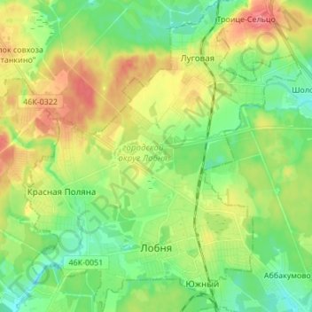
Name: Lobnia topographic map, elevation, terrain.
Location: Lobnia, Oblast de Moscou, District fédéral central, Russie (55.99475 37.40858 56.07087 37.53046)
Average elevation: 197 m
Minimum elevation: 172 m
Maximum elevation: 233 m
Other topographic maps
Click on a map to view its topography, its elevation and its terrain.
Ока
Ока, городской округ Луховицы, Oblast de Moscou, District fédéral central, 140530, Russie
Average elevation: 103 m
Дмитровский городской округ
Дмитровский городской округ, Oblast de Moscou, District fédéral central, Russie
Average elevation: 175 m