Geolocate

Hutton topographic map

Click on the map to display elevation.

About this map

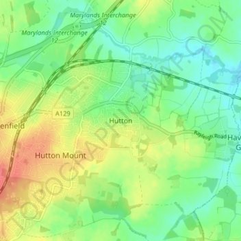
Name: Hutton topographic map, elevation, terrain.

Location: Hutton, Brentwood, Essex, England, CM13 1QR, United Kingdom (51.61033 0.33576 51.65033 0.37576)

Average elevation: 66 m

Minimum elevation: 45 m

Maximum elevation: 98 m

Gear up for your next adventure:

🧯Animal Deterrent Spray - Safety spray for wildlife
💡Collapsible Camping Lanterns - Illuminate your base camp or tent for map studying at night
🥤Outdoor Water Bottles - Reusable bottles for outdoor activities
🐍Snake Gaiters - Protection against snake bites
📡Satellite Messengers - Emergency communication devices

As an Amazon Associate, this site earns from qualifying purchases at no extra cost to you.